|
The
2004 EXPEDITION
Since
1984, Greg Deyermenjian and his team have been making scientific
expeditions into the high and lower altitude jungle areas
north and northeast of Cusco, Peru. Sponsored over the years
by The Explorers Club; a Shipton-Tilman Grant from Gore Tex;
and the Polartec Performance Challenge Award; the team welcomed
its 2004 Expedition sponsor, Eastern Mountain Sports. Support
from such prestigious sponsors is partly from the team's unquestionable
reputation for scientific integrity and ethical conduct in
both the execution and documentation of their findings- not
to mention a passion beyond words.
"This
expedition was the most ambitious and significant to date.
We aimed to unearth new, historical evidence of the presence
of the last Incas in this region- which we did- but more importantly,
to assert that the quest for Paititi must continue- given
the strategic location of these ruins along or near the Inca
Road of Stone so far north." -G. Deyermenjian.
THE
QUEST
Cusco-
direction Callanga
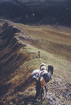
The team traveled by vehicle north of Cusco into the highland
routes toward the jungles east in altitudes that exceed 4,000
meters. Documented ruins.
Return
to Cusco
Returned to Cusco for fresh supplies. To conserve time and
energy, the team hired a helicopter in Cusco to travel into
the mountain jungle.
Inca
Road of Stone and Lago de Angel
The helicopter dropped the team deep into the Pantiacolla
area near the Lago de Angel. The team attempted to follow
and map forgotten parts of the Inca Road of Stone up to an
unexplored zone of the Pantiacolla Plateau- tracking important
milestones at the Lago de Angel. Ruins and caves documented.
Following
the trail down into the nearly impenetrable cloud-forest,
and then climbing up to the highlands the team found the mysterious
"8-shaped" lake that is now known as "Lago
de Angel." The stonework of an ancient Incan presence
around the lake seemed to continue on, ever northwestward.
Explore
beyond Lago de Angel
GPS technology helped the team track their position along
the way, while the wisdom and expertise of their Machiguenga
guide, Goyo, would lead them toward the Rio Timpia.
At nearly 11,000 feet altitude, another platform of asymmetrical
form, being shaped like a pointed bullet, with five sides,
its tip pointed northeast. Its location offered a commanding
view of two distinct river systems, that of the Yavero far
below to the west, and that of the Timpia and its uppermost
tributaries to the east.
Rio
Timpia
They continued their journey around the headwaters of the
Rio Ticumpinca toward the Rio Timpia, the furthest northern
exploration yet. Slashing their way through thick, centuries-old
vegetation, the team pushed ahead to an area where their most
important ruins to date were found. Platforms discovered.
Incan compound.
The
location of the platform--at 12 degrees, 25.5 minutes south
latitude, by 72 degrees, 11.5 minutes west longitude--mark
it as the furthest Incan vestige to be found directly north
of Cusco,
and the area as the furthest reach of the land mass which
makes up the Meseta de Pantiacolla. And those dark ranges
beyond constituted a blank space on the U.S. Department of
Defense/ Peruvian Instituto Geografico Nacional's satellite-generated
maps, an area labeled "DATOS INSUFICIENTES,"insufficient
data, impenetrable as yet to the eye in the sky. -Deyermenjian.
Lake
of Suchi Cocha
These zones form a perimeter bearing strong evidence of Inca
civilization, extending along the Paucartombo cordillera in
the south toward the Toporake Plateau further north. Ruins
found.
Click
here to read about past expeditions
|