|
:::
QUEST FOR PAITITI FIELD JOURNAL :::
ENTRY FOURTEEN (June 18, 2004) "ONWARD"
From Quebrada
we headed south, following, in reverse, the course
of the Rio Yanatile. When we reached the town of Amparaes--almost
entirely built with stone from past Incan dwellings--we headed
up a smaller dirt road, up into the Cordillera de Lares to
our northeast. Hours later we disembarked at a campesino stone
hut beside a lake. Here we stayed with Sr. Don German Cardeña,
a gentleman most knowledgeable of local legend. His very house
was atop what had been an Incan living and burial area. And
the lake here was the famous "Puno Cocha," the place
into which legend had the Incas themselves, on their way through
this place on their flight toward the east, throwing their
excess "chuño," dehydrated
potatoes that in bulk were weighing them down and impeding
their
flight towards the selvas, the jungles. Paulino himself waded
into its waters, bent down and extracted from the perpetually
frigid waters at lake-bottom the blackened skins of chuño
still there.
The next
morning we went further, on foot, toward the northeast, to
the ancient, and still-inhabited, town of Huaylla, where we
enlisted the services of a local man to accompany us, and,
continuing onward, just before we came to the Rio Mapacho,
there we found ourselves in the midst of a complex of Incan
ruins. This was the site of Tambocancha. It was almost fully
covered in thorny "maleza," weeds and undergrowth.
We carefully uncovered enough of the site with expertly wielded
machetes to be able to document through film and photograph
what had once been a major center, guarding the approaches
to the highlands from the jungles to the east. It could have
well been a an important regional center in the Inkanato,
the Incan times, maybe a capital of the Antisuyu, the eastern
quarter of the Incan world. It had walls with many niches,
large and small,
all well-built of well fitted-together stone. And its location
placed it right across the river from the Cordillera de Paucartambo,
upon which was the Incan "Camino de Piedra," the
road of stone which traversed the crests of that range. And
it was this Incan road that went ever northward, as had we,
toward the jungles of Callanga and Mameria with their ancient
stone "masma" constructions and storehouses; through
the Meseta of Toporake, with its broad barracks-like structures,
and onward toward the Timpia, and the Lago de Angel, and the
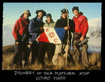
"plataformas" of Ultimo Punto, where we would one
day begin again our quest for "Paititi," for even
further reaches of the ancient Inca into territory still blank
on the map...
~ Greg Deyermenjian
      
      
|